

India’s cities are expanding at a pace never seen before. With rapid urbanization, population growth, and increasing demand for infrastructure, urban planners and government authorities are constantly searching for smarter ways to manage land, roads, buildings, and natural resources. In this transformation, one powerful technology is quietly reshaping how cities are monitored and planned — Lidar-equipped drones.
Once considered a niche technology used mainly in defense or specialized research projects, Lidar drones are now becoming an essential tool for urban development across India. By providing highly accurate three-dimensional maps of landscapes and infrastructure, these drones are helping governments detect illegal constructions, rediscover lost water bodies, improve city planning, and prepare for natural disasters.
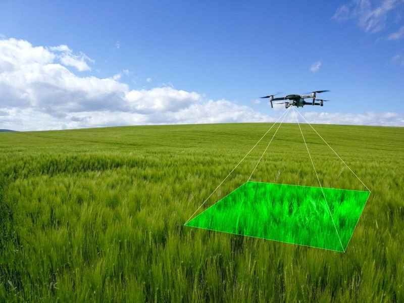
Lidar, short for Light Detection and Ranging, is a remote sensing technology that uses laser pulses to measure distances between the sensor and the earth’s surface. When mounted on drones, Lidar sensors send thousands of laser beams every second toward the ground. These beams bounce back after hitting objects like buildings, trees, roads, or terrain.
By measuring the time it takes for the laser light to return, the system calculates extremely precise distance measurements. The result is a detailed 3D digital map of the landscape, often accurate to a few centimeters or even millimeters.
What makes Lidar especially powerful is its ability to penetrate vegetation and capture ground details hidden beneath tree cover or urban clutter. This capability makes it far superior to traditional aerial photography or manual land surveys.
Traditional land surveys require teams of engineers to physically measure distances and elevations on the ground. This process is slow, expensive, and prone to human error. Surveying even a small urban area can take weeks or months.
Lidar drones dramatically reduce this time.
A single drone equipped with Lidar can survey up to 10 square kilometers in just a few hours, producing highly accurate 3D data that can be analyzed immediately. This speed and precision make Lidar drones invaluable for city authorities managing complex urban environments.
Additionally, drones can access areas that are difficult or dangerous for survey teams, such as flood zones, dense forests, construction sites, or congested city centers.
Across India, municipal corporations and government agencies are increasingly adopting drone-based Lidar surveys as part of modern urban governance.
Several cities have already launched large-scale mapping projects:
Hyderabad has used drone surveys to identify illegal layouts and unapproved residential developments that have emerged on government land.
Delhi has deployed drones to map the Yamuna floodplains, helping authorities monitor encroachments and prepare for seasonal flooding during the monsoon.
Pune has used aerial mapping to improve property tax assessments. By comparing drone data with official records, authorities have identified thousands of undeclared structures that were previously missing from municipal databases.
Mumbai, after facing severe flooding in 2021, initiated drone mapping projects to redesign its stormwater drainage systems and improve flood resilience.
These initiatives are not isolated experiments. They are part of India’s broader Smart Cities Mission, which aims to use digital technologies and geospatial data to improve urban infrastructure and governance.
As Lidar drones scan Indian cities, they are revealing insights that were previously hidden from planners and policymakers.
One of the most common discoveries is unauthorized construction. Entire colonies and buildings have been found occupying government land, forest areas, and floodplains. Because these structures often lack official approval, they were not visible in government records.
Drone data provides undeniable evidence, helping authorities take corrective action.
In many Indian cities, traditional lakes, ponds, and canals have gradually disappeared due to urban expansion. However, Lidar mapping has helped rediscover the original boundaries of these water bodies beneath layers of development.
This information is critical for restoring natural drainage systems and preventing urban flooding.
In states like Rajasthan and Karnataka, drone surveys have also helped archaeologists locate previously unknown historical structures such as ancient stepwells, forts, and temple remains buried under vegetation or modern construction.
These discoveries highlight the cultural value of advanced mapping technologies.
Lidar scans have also exposed planning flaws in rapidly growing cities. Misaligned roads, overlapping underground pipelines, poorly designed drainage systems, and unplanned settlements are now visible in detailed 3D maps.
With this data, city planners can redesign infrastructure and avoid costly mistakes in the future.
Although Lidar mapping may seem like a technical tool used only by engineers or government agencies, it has direct benefits for ordinary citizens.
Real Estate Transparency
Homebuyers and investors can access accurate spatial data before purchasing property. This helps avoid disputes over land boundaries, illegal constructions, or flood-prone zones.
Better Traffic Planning
Detailed road mapping allows authorities to redesign intersections, highways, and public transport routes, reducing congestion and improving daily commuting.
Article link – https://www.sunconengineers.com/lidar-drones-survey-and-mapping-indian-cities/
Improved Disaster PreparednessHigh-resolution terrain models help predict flood risks, landslides, and drainage problems. This allows governments to take preventive measures before disasters occur.
Cleaner and Safer Cities
Drone monitoring can quickly identify illegal dumping areas, unauthorized construction, and environmental violations, enabling faster enforcement and urban management.
The next stage of urban mapping in India involves combining Lidar data with artificial intelligence (AI).
AI algorithms can analyze drone-collected data to predict urban trends such as population growth, traffic patterns, and infrastructure demand. For example, future systems could forecast where traffic congestion will increase over the next five years and recommend road expansions or public transport improvements today.
India’s Geospatial Policy 2022 has also opened the door for private companies and startups to contribute to mapping and geospatial innovation. This policy encourages collaboration between government agencies, technology firms, and research institutions.
As a result, the country is likely to see rapid growth in drone mapping companies, urban analytics platforms, and geospatial data services.
Cities are complex ecosystems where land, infrastructure, environment, and human activity intersect. Managing them effectively requires accurate and up-to-date information.
Lidar drones are giving India something it has never had before — a clear, comprehensive view of its cities from the sky.
By revealing hidden structures, rediscovering natural landscapes, and identifying planning challenges, drone technology is helping authorities make better decisions for sustainable urban development.
As these technologies continue to evolve, the maps guiding India’s future cities will become smarter, more detailed, and more dynamic.
The next time you see a drone flying overhead, it may not just be capturing images — it might be quietly helping redraw the blueprint of the city beneath your feet.

© 2025 Crivva - Hosted by Airy Hosting Managed Website Hosting.