Hydrographic surveys are essential for mapping and analyzing underwater environments, supporting industries such as marine construction, offshore energy.
Hydrographic surveys play a crucial role in understanding and mapping bodies of water, aiding in navigation, construction, and environmental management. As an integral part of geotechnical services, hydrography provides essential data for industries such as marine construction, offshore energy, and environmental conservation.
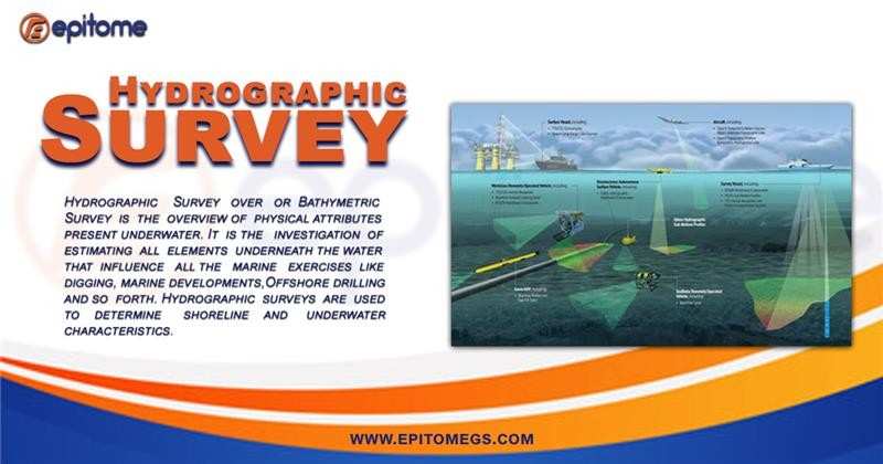
A hydrographic survey is the process of measuring and describing underwater terrain, water depth, and seabed characteristics. It involves the use of advanced sonar technology, GPS, and data-processing software to create accurate maps of water bodies, ensuring safe navigation and efficient maritime operations.
Choosing expert geotechnical services for hydrographic surveys ensures accuracy, efficiency, and compliance with industry standards. Here’s why professional expertise is essential:
1. Precision and Accuracy
Expert geotechnical teams utilize advanced hydrographic survey equipment such as multibeam echo sounders, side-scan sonar, and LiDAR. This ensures high-resolution mapping of underwater topography, reducing errors and improving data reliability.
2. Compliance with Industry Standards
Professional geotechnical services adhere to international hydrographic survey standards set by organizations like the International Hydrographic Organization (IHO). Compliance ensures that survey data is accurate and suitable for engineering, construction, and navigation projects.
3. Customized Survey Solutions
Every project has unique requirements. Geotechnical experts assess project-specific needs and tailor hydrographic surveys accordingly, whether for dredging, offshore construction, or environmental monitoring.
4. Efficient and Cost-Effective Operations
With experience in handling complex hydrographic projects, expert geotechnical teams optimize time and resources, minimizing delays and reducing operational costs without compromising data quality.
5. Advanced Data Processing and Interpretation
Beyond data collection, expert geotechnical services provide in-depth analysis using cutting-edge software. They interpret seabed conditions, sediment types, and underwater hazards, aiding in better decision-making for construction, resource extraction, and coastal management.
6. Environmental Considerations
Professional hydrographic surveys consider environmental sustainability, minimizing ecological disturbance while collecting accurate data. This is particularly crucial for projects in sensitive marine ecosystems.
Importance of Hydrographic Surveys in Geotechnical Services
Hydrographic surveys are indispensable in geotechnical studies as they provide:
Bathymetric Mapping – Determines water depth and underwater topography, essential for port development and dredging operations.
Seafloor Characterization – Identifies sediment composition and geological formations, crucial for offshore oil, gas, and renewable energy projects.
Coastal Erosion Monitoring – Helps assess changes in shorelines, ensuring effective coastal management strategies.
Environmental Assessments – Supports marine conservation efforts by identifying sensitive habitats and pollution sources.
Navigation Safety – Ensures ships, submarines, and offshore structures operate in safe waters by detecting underwater hazards.
Advanced technology has transformed hydrographic surveys, improving accuracy, efficiency, and data collection for marine navigation, offshore construction, and environmental monitoring.
Key Technologies:
Multibeam & Single-Beam Echo Sounders – Provide precise depth measurements and 3D mapping of the seafloor.
Side-Scan Sonar – Captures detailed seabed images, detecting underwater objects and hazards.
Sub-Bottom Profilers – Analyze sediment layers and underwater geological structures.
LiDAR (Light Detection and Ranging) – Maps shallow waters using laser pulses, ideal for coastal surveys.
AUVs & USVs – Autonomous underwater and surface vehicles conduct deep-sea and hazardous-area surveys.
GPS & GNSS – Ensure accurate positioning for seamless geospatial mapping.
Satellite & Remote Sensing – Monitors coastal changes and marine environments.
Conclusion
Advanced technology has significantly enhanced the accuracy, efficiency, and scope of hydrographic surveys. With innovations like multibeam sonar, LiDAR, AUVs, and AI-driven data processing, surveys are now faster, more precise, and environmentally sustainable. These advancements play a crucial role in marine navigation, offshore construction, and coastal management, ensuring safer and more informed decision-making.