Discover top advanced hydrographic survey solutions by Epitome Experts for accurate mapping.
In an era where marine infrastructure is rapidly evolving and coastal development is at an all-time high, the importance of accurate and reliable hydrographic surveys cannot be overstated. At Epitome Geotechnical Services, we specialize in delivering cutting-edge hydrographic survey solutions that help our clients navigate the complexities of underwater environments with confidence.
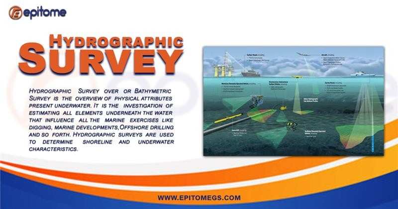
A hydrographic survey involves the measurement and mapping of features below the surface of water bodies such as oceans, rivers, harbors, and lakes. These surveys are essential for a wide range of applications, including:
Nautical charting
Port and harbor development
Dredging operations
Underwater pipeline and cable routing
Offshore construction
Environmental assessments
By using advanced technologies such as multibeam and single-beam echo sounders, side-scan sonar, and GNSS positioning systems, we provide high-resolution bathymetric data critical for planning, design, and safe navigation.
At Epitome, precision, safety, and reliability are the cornerstones of our hydrographic survey operations. Our team comprises seasoned hydrographers, marine engineers, and geospatial experts who bring a wealth of experience to every project. Here’s what sets us apart:
1. Advanced Technology
We utilize state-of-the-art equipment including:
Multibeam echo sounders for detailed seafloor mapping
Side-scan sonar for seabed imagery
RTK-GNSS for real-time positioning accuracy
Data processing software that ensures clear, actionable insights
2. Customized Solutions
Every project is unique. Whether it’s a nearshore development, a dredging campaign, or a port expansion, we tailor our survey methodologies to meet specific project needs and environmental conditions.
3. Commitment to Quality and Safety
Our operations follow strict quality assurance protocols and adhere to international hydrographic standards, including those set by the International Hydrographic Organization (IHO). Safety is at the core of everything we do—both for our team and the environment.
Our hydrographic services are vital for sectors such as:
Marine construction: Ensuring accurate design and alignment for offshore structures
Oil & Gas: Supporting pipeline and subsea installation
Port Authorities: Managing siltation and dredging programs
Environmental Monitoring: Mapping habitats and assessing marine ecosystems
The future of hydrographic surveying is fast, accurate, and data-driven—and Epitome Geotechnical Services is leading the way.
As marine development, offshore energy, and climate resilience projects grow, the demand for high-precision underwater data is skyrocketing. With advancements in autonomous survey vessels (ASVs), AI-powered data processing, and real-time 3D mapping, hydrographic surveys are becoming more efficient and insightful than ever before.
At Epitome, we’re embracing these innovations—combining cutting-edge technology with expert analysis to deliver faster results, better accuracy, and smarter decisions for every marine project.
Conclusion
As we navigate toward a more connected, sustainable, and technologically advanced world, the role of hydrographic surveying is more critical than ever. At Epitome Geotechnical Services, we’re not just adapting to the future—we’re helping shape it. By combining innovation with deep industry expertise, we deliver the underwater insights that power smarter infrastructure, safer navigation, and a better understanding of our marine environments.