Discover how hydrographic surveys play a vital role in enhancing Epitome Geotechnical Services
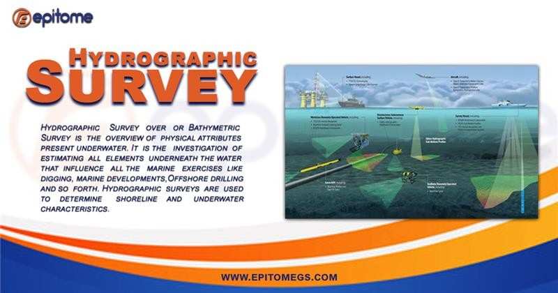
Hydrographic Survey compass the measurement, description, and analysis of physical features in bodies of water and their surrounding environments. These services are essential for safe navigation, coastal management, marine construction, resource exploration, and environmental protection. By collecting accurate and detailed data about the underwater terrain, water depths, tides, currents, and seabed composition, hydrographic services provide the foundation for informed decision-making in marine projects.
Epitome Geotechnical Services involve the investigation, analysis, and assessment of soil, rock, and other subsurface materials to determine their suitability for construction and engineering projects. These services are essential for designing safe and durable foundations for infrastructure built on or near the seabed, such as offshore wind farms, oil platforms, ports, bridges, and coastal facilities.
By understanding the physical, mechanical, and chemical properties of the subsurface, geotechnical experts can predict how different materials will respond to various loads and environmental conditions.
Soil Testing and Analysis
Soil testing and analysis are crucial parts of geotechnical services, aimed at understanding the physical and chemical properties of soil to determine its suitability for construction. After collecting soil samples through drilling, engineers conduct various tests to assess factors like strength, compressibility, permeability, and grain size.
Seismic Surveys:
Engineers use sound waves to map out what’s beneath the seabed. By studying how the waves bounce back, they can spot weak spots, rock layers, or faults that could cause problems for construction.
Foundation Design:
Based on all the data collected, engineers design strong and stable foundations that can handle the weight and pressure of whatever structure is being built.
Geotechnical Reports:
All findings are put together in a report with recommendations for building safely and avoiding risks. These reports are essential for planning and getting approval from regulatory bodies.
Bathymetric Surveys:
Bathymetric surveys involve mapping the underwater topography to determine water depth, identify hazards, and produce detailed charts. Using technologies like sonar, LiDAR, and multibeam echo sounders, these surveys generate precise 3D models of the seafloor. This information is crucial for navigation safety, dredging operations, offshore construction, and habitat mapping.
Seabed Mapping:
Understanding the characteristics of the seabed is critical for construction, anchoring, and laying underwater pipelines or cables. Seabed mapping identifies sediment types, rock formations, and other geological features. It also aids in assessing potential environmental impacts and designing suitable foundations for offshore structures.
Navigation Charting:
Producing reliable nautical charts is one of the primary functions of hydrographic services. These charts are essential for safe maritime navigation, helping vessels avoid underwater hazards, identify safe passage routes, and comply with regulatory requirements.
Hydrographic Data Analysis:
The collected data is processed and analyzed to generate reports, models, and charts that guide decision-making. Whether it’s designing a new port, planning an offshore wind farm, or monitoring coastal erosion, the analysis phase ensures data accuracy and relevance.
Hydrographic Survey and analysis offer several key benefits that are essential for safe and successful construction projects:
Ensures Structural Stability: By understanding soil strength and compressibility, engineers can design foundations that can safely support the weight of structures without risk of sinking, shifting, or collapsing.
Prevents Costly Failures: Early detection of weak or unstable soil prevents unexpected issues during construction, saving time and money by avoiding structural failures or the need for redesigns.
Improves Safety: Identifying potential hazards like loose soil, high water tables, or seismic vulnerabilities helps reduce safety risks for workers and future users of the structure.
Optimizes Design: Detailed soil analysis allows engineers to choose the most suitable construction techniques and materials, enhancing efficiency and durability.
Aids in Regulatory Compliance: Soil testing reports are often required to meet local, national, and international construction standards, ensuring projects are approved and legally compliant.
Supports Environmental Protection: Assessing soil permeability and composition helps minimize environmental impacts by guiding drainage systems and erosion control measures.
Boosts Project Efficiency: With accurate soil data, engineers can make informed decisions that streamline planning, reduce delays, and keep projects on schedule.
Soil testing and analysis are fundamental to the success of any construction project, especially when dealing with complex offshore or coastal environments. By providing critical insights into soil strength, composition, permeability, and other essential characteristics, these services help engineers design safer, stronger, and more reliable structures.